
Los Caminos Antiguos Scenic and Historic Byway
Romeo to the Rio Grande

Main Street in Romeo, above and below


Romeo is just across the tracks of the Denver & Rio Grande Western from US 285. Turning east onto Colorado 142 puts you on Main Street. Like most of the San Luis Valley, it has seen more prosperous days. But it's still a quaint little town surrounded by some very fertile agricultural land and I would imagine it has some local history of its own. Two miles due east of here is the town of Manassa, one of the first major Mormon settlements in the Valley but best known for one of its' native sons: Jack Dempsey, once the World Heavyweight Boxing Champion. The restored log home pictured above is where he was born and grew up. Today it is a museum in the heart of Manassa and seems to be the primary local tourist attraction, filled as it is with memorabilia of Jack Dempsey and the times he lived in.
Manassa was settled by the Mormons in 1879. They did well here, slowly growing their community and later moving out to build Richfield and Sanford, adding them to the Manassa Stake about 50 years ago. While Manassa is a clean and well-kept little town, like most of the San Luis Valley, nearly all business these days takes place in Alamosa (and that's where the sales taxes stay).

The Manassa LDS Church, probably the largest structure in town

The Catholic church in Manassa

Coming east out of Manassa, a field of wild irises in the foreground, the Pinon Hills in the distance

Flat Top, north of the Scenic Byway

The Pinon Hills, south of the Scenic Byway
From Romeo to Manassa the landscape along the Scenic Byway gets drier and then almost dries up east of Manassa. The road crosses the North Branch of the Conejos River and then the Rio San Antonio before heading into the San Luis Hills. Most of the San Luis Hills are owned by the BLM and are classed as an "Area of Critical Environmental Concern." While the San Luis Hills also run east of the Rio Grande, that land was part of the San Luis Land Grant before the Americans came and was not originally claimed nor surveyed by the American government.

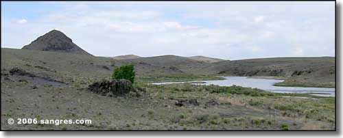
Volcanic plugs, southeast of Flat Top

Another point in the Pinon Hills, south of the Scenic Byway
All through this beautiful area there are side roads leading off into the barrens. Steep canyons, sheer rock walls, sandy streambeds and occasional springs indicated by clumps of trees beckon. I didn't see much in the way of wildlife out here but I know this Valley is full of elk and mule deer. The Valley is also visited regularly by large flocks of migrating birds in spring and fall.

Looking southeast across the Rio Grande
Because of irrigation in the Valley, the Rio Grande looks very tame now but 150 years ago, when John Fremont came through here, the river was more than 250 feet wide and at least 10 feet deep. Crossing it was a life-and-death struggle for many years.
Looking northwest up the Rio Grande Valley, Sugar Loaf in the background
