 |
Twin Falls, Idaho |
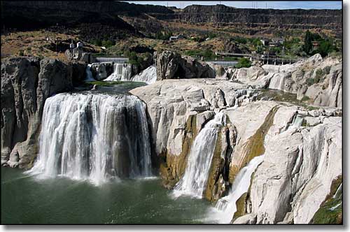 Shoshone Falls (higher than Niagara Falls by 36') |
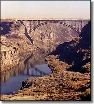 The northern city limit of Twin Falls is right against the Snake River Canyon. Shoshone Falls is about 5 miles east of the city limits and Twin Falls is still further upstream. About 1.5 miles upstream of the Perrine Bridge (pictured on the left) is Pillar Falls. The northern city limit of Twin Falls is right against the Snake River Canyon. Shoshone Falls is about 5 miles east of the city limits and Twin Falls is still further upstream. About 1.5 miles upstream of the Perrine Bridge (pictured on the left) is Pillar Falls.
The Twin Falls area has seen human habitation for something like the last 14,500 years. In 1959, excavations at the Wilson Butte Cave near Twin Falls produced arrowheads and other evidence of human activities that date among the oldest human artifacts found in North America. More recently, the area was dominated by the Bannock and Northern Shoshone Tribes, prior to the invasion of barbarians from Europe. The first Europeans to travel through the Twin Falls area were with the Wilson Price Hunt expedition in 1811-1812. They were trying to forge an all-water route from St. Louis, Missouri to Astoria, Oregon. They met with disaster in the rapids just upstream from Twin Falls near present-day Murtaugh. Robert Stuart led a successful overland expedition from Astoria to St. Louis that also passed by the Twin Falls area in 1812-1813. The trail he blazed later became the main route of the Oregon Trail. In those days, the Twin Falls area was considered particularly inhospitable owing to the Snake River Canyon, the waterfalls, the rapids and the parched conditions in the surrounding lands. A stage stop was established at Rock Creek (near the present townsite of Twin Falls) in 1864 but agricultural operations in the area were limited to the bottom of the canyon. In 1903, I.B. Perrine, a rancher and farmer from the canyon bottom, got private financing and built the Milner Dam on the Snake River near Caldron Linn. The canal system that was then built from that lake finally made development of the lands above the canyon rim possible. Twin Falls was a planned community, designed by Emmanuel Louis Masqueray in 1904. Proceeds from sales of the town lots went toward building more irrigation canals in the area. As celebrated an architect as Masqueray was at the time, he laid the city out in a northwest-southeast and northeast-southwest pattern. The northwest to southeast streets were numbered and named avenues while the northeast to southwest streets were numbered and named streets. It created a lot of confusion with the corner of "3rd and 3rd" (for example) being possible in more than 1 location. In 2003, the city renamed the northeast to southwest streets to end the problem. Twin Falls grew quickly as an agricultural and economic center because that irrigation water was all the dry but fertile countryside needed to grow a number of agricultural commodities. Since 1975, Twin Falls has diversified its economic base with the construction of facilities for Dell, Inc. (computers), Jayco (recreational vehicles) and Glanbia plc. (cheese and nutritional ingredients). The College of Southern Idaho is located in Twin Falls and operates a refugee center that has helped to bring in and resettle refugees from places like the former Soviet Union, Bosnia and Herzegovina. The University of Idaho, Idaho State University and Boise State University offer courses on the CSI campus. |
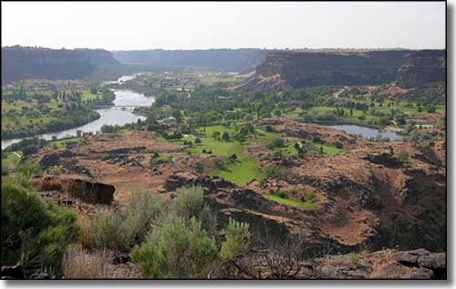 Blue Lakes Country Club in the Snake River Canyon near Twin Falls, Idaho |
| Fast Facts about Twin Falls, Idaho |
|
Twin Falls, Twin Falls County, ID 83301, 83303
Incorporated: 1904 Elevation: 3,745' Latitude: 42.578°N Longitude: 114.475°W Resident Racial Breakdown: White Non-Hispanic: 84.0% Hispanic: 12.3% Asian: 1.0% Native American: 0.5% African-American: 0.2% Other: 0.2% Two or More Races: 1.9% Education: High School or Higher: 81.5% Bachelor's Degree or Higher: 16.5% Graduate or Professional Degree: 5.4%
2009 Estimates: Population: 42,741 Males: 20,535 Females: 22,206 Median Resident Age: 33.8 Years Estimated Median Household Income: $37,100 Estimated Median Home Value: $125,500 Population Density: 3,456 People per Square Mile 2011 Cost of Living Index for Twin Falls: 86.1 Major Industries: Health Care, Construction, Food Processing, Educational Services, Lodging & Food Services, Agriculture, Professional Services, Government, Social Services Unemployed (March 2011): 9.3% |
|
|
 |
| Index - Arizona - Colorado - Idaho - Montana - Nevada - New Mexico - Utah - Wyoming National Forests - National Parks - Scenic Byways - Ski & Snowboard Areas - BLM Sites Wilderness Areas - National Wildlife Refuges - National Trails - Rural Life Advertise With Us - About This Site - Privacy Policy |
| Photo of the Snake River Canyon courtesy of Wikipedia userid Faustus37 Photo of the Perrine Bridge over the Snake River Canyon courtesy of Heather Dillon, CCA 3.0 License. Text Copyright © by Sangres.com. All rights reserved. |