
Fort Stanton-Snowy River Cave
National Conservation Area

Snowy River Cave

Carved out of the Mescalero Apache homelands in the foothills of the Sierra Blanca Mountains, Fort Stanton-Snowy River Cave National Conservation Area is composed of 25,080 acres of the old Fort Stanton Military Reservation. In the 1850's, the US Cavalry stationed the 9th and 10th Cavalry here. After the Civil War, the famous 24th and 25th Infantry Buffalo Soldiers were stationed here. Fort Stanton is also one of those names mentioned in regards to Billy the Kid, Kit Carson and General "Black Jack" Pershing. The post was a Merchant Marine tuberculosis sanatorium and hospital for awhile. In World War II it served as a prisoner of war camp for both German and Japanese prisoners. In 1953 the federal government turned the property over to the state and New Mexico operated a state hospital and training school here until 1955. The Fort itself is still operated as a Museum and is open only on a limited basis.
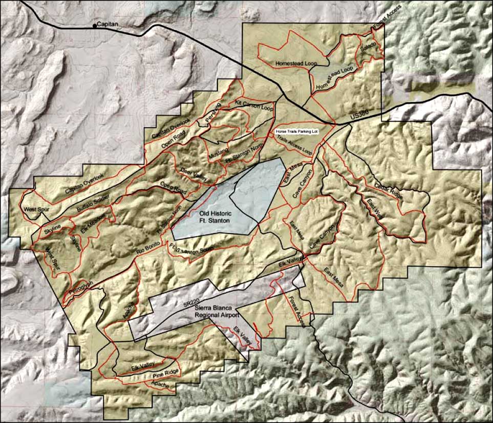
Today, Fort Stanton-Snowy River Cave National Conservation Area (on land surrounding the Fort) has some 360 miles of hiking, mountain biking and horseback riding trails winding through open meadows, rolling hills and mesas. These trails offer great views of the Capitan Mountains and Sacramento Mountains to the north and south. Fort Stanton is the site of an annual horse endurance event that is now up to 6 days long.
Also on the property is the Fort Stanton Cave with 11 miles of mapped passages, making it the 3rd longest cave in New Mexico. If you want to explore you'll need a permit and your own caving equipment: this is an undeveloped "wild" cave. The cave is only open to exploration from April 15 to November 1. Fort Stanton Cave contains aragonite, selenite needles, helictites, and various gypsum formations, but is best known for its rare velvet formations. The cave is closed in the winter to protect the bats hibernating inside. Snowy River Cave is one of the more significant passages within the overall cave. The name comes from a bright white crystal calcite formation that runs along the floor of the passage. About 5 miles of Snowy River Cave has been mapped so far and exploration continues sporadically.
Another feature of the Fort Stanton-Snowy River Cave National Conservation Area is Petroglyph Rock, a feature on the Petroglyph Trail along the Rio Bonito. Etched into the rock is artwork left by the Jornada Mogollon, an ancient people that we know little about.
Fort Stanton-Snowy River Cave National Conservation Area has no formalized camping areas but is open to dispersed overnight camping with a 14-day stay limit. The majority of trails begin at the Horse Trails Parking Lot on NM 220. There's hitching rails, stock water and a restroom there. Camping is also allowed at that parking lot.
Mountain bikers, horseback riders and hikers are strongly encouraged to stay on the established trails, although cross-country hiking and horseback riding is allowed.
In 2008, Bill Richardson (governor of New Mexico) announced plans to turn Fort Stanton into a living history venue and convert the site into the Fort Stanton State Monument. Funds were set aside to renovate the remaining officers quarters, headquarters and stables.
To get there: go east from Capitan on US 380 for 4.25 miles, then turn south on NM 220. From Lincoln go west on US 380 for 7.7 miles, then turn south on NM 220. The horse trails parking lot is about 1 mile from US 380 on NM 220, the Fort Stanton Museum being another mile further on NM 220.
Maps: BLM - Carrizozo, Ruidoso

Fort Stanton-Snowy River Cave NCA area map
Lincoln National Forest - White Mountain Wilderness - Capitan Mountains Wilderness
Billy the Kid Trail - Lincoln State Monument - Smokey Bear Historical Park
Valley of Fires Recreation Area - Three Rivers Petroglyph Site - Ski Apache
Photo Galleries - Unique Features - BLM Sites - Outdoor Sports & Recreation
New Mexico's National Forests - Wilderness Areas - New Mexico's National Parks
National Wildlife Refuges - Ski & Snowboard Areas
