Bridger-Teton National Forest


Bridger-Teton National Forest contains more than 3.4 million acres of the finest countryside in western Wyoming. A large part of the Greater Yellowstone Ecosystem, Bridger-Teton also contains nearly 1.2 million acres of designated wilderness.
The northwestern boundary of Bridger-Teton is against Yellowstone National Park. The western boundary is against Grand Teton National Park and the National Elk Refuge. A large part of the eastern boundary of the Forest is along the crest of the Continental Divide.
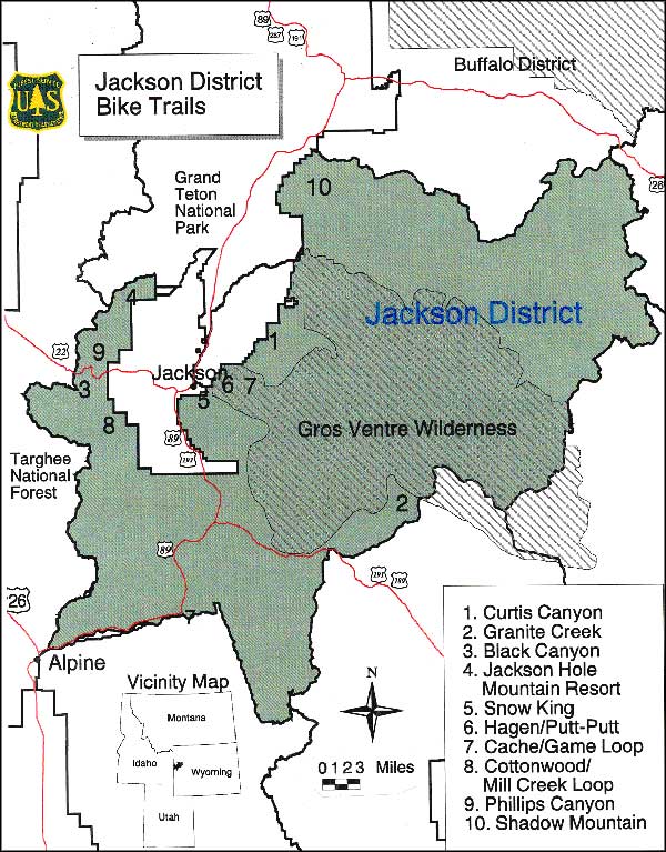
Bridger-Teton National Forest offers more than 2,200 miles of trails that vary in difficulty from easy family day hikes to multi-day adventures in hard-core, high mountain wilderness. There are also thousands of miles of streams and rivers in the Forest that are enjoyed by fishermen and canoeists, but the adrenaline junkies who prefer rafts and kayaks all flock to the Lower Snake, Gros Ventre and Hoback Rivers to enjoy some of the finest whitewater and most spectacular river canyons in Wyoming.
Bridger-Teton National Forest offers 37 developed campgrounds, and thousands of dispersed (undeveloped) campsites. However, campers need to be aware that there's bears in these woods: grizzly bears in particular.
There are special precautions that you really need to take in regards to your food and garbage storage, for your own safety as much as the bear's. Most of the developed campgrounds on the Bridger-Teton are "RV challenged:" large RV's just don't do well here. And even in the developed campgrounds, the facilities vary widely.


Bridger-Teton is home to many species of birds and mammals, and when fall hunting season arrives, the campgrounds may be closed but the elk, deer, moose, bighorn sheep, coyotes, grey wolves, black bears, grizzly bears... well, there's enough critters in these woods to make many a big game hunter drool (although it's not legal to be shooting the grizzlies or the grey wolves in particular).
Among the birds on the Forest you'll find trumpeter swans, bald eagles, sandhill cranes, red-tailed hawks, falcons, turkey buzzards, even the odd pelican...
There's hundreds of miles of Forest Service and old logging roads in these woods for 4WD and OHV's, but getting off those roads and heading straight cross country is kinda frowned on, seriously. Mountain bikes are good everywhere except in the wilderness areas.
One thing, though, the snow starts coming down early here. These mountains are high and rugged. That's why there's places like Jackson Hole Mountain Resort, Snow King Ski Area and Pine Creek Ski Area out here. Sometimes a little snow isn't good, but a lot of snow...
Winter brings out the snowboarders, downhill skiers, cross-country skiers, snowshoers, dog sledders, and ice climbers. There's also several hundred miles of groomed and maintained snowmobile trails in the Forest, some of which network with the Continental Divide National Scenic Trail, a hiking trail that isn't complete yet but still passes most of the way from Canada to Mexico either on or very close to the Continental Divide.


Another popular hiking trail is the Wyoming Range National Recreation Trail, 75 miles of easy to difficult hiking along the crest of the Wyoming Range. Some sections of the trail are steep while some are poorly marked and indistinct. Much of the trail is above 9,000', on the high ridge tops and out in the open parks where humans make excellent lightning rods in season. But is there any better way or place to practice and hone your skills as a modern mountain man or woman? The trail does make its way to the top of Wyoming Peak (11,418') for some truly magnificent views.
One popular place to visit is the Gros Ventre Slide. Back on June 23, 1925, after several days of rapid snow melt and heavy rain, a one mile section of Sleeping Indian Mountain decided to let go and slide down into the valley, forming a natural dam across the Gros Ventre River. Lower Slide Lake filled up over the next couple of years but a heavy flood on May 17, 1927, washed away part of the dam and the resulting catastrophic drop in the lake's water level washed the town of Kelly almost off the map. This is now a designated National Geologic Area with an interpretive trail snaking its way through the slide debris enabling visitors to learn about the geology, ecology and history of the event. This unique site is about 18 miles northeast of Jackson on a dirt road that passes by what remains of Kelly before reaching Lower Slide Lake.
Another often visited spot is in the Greys Ranger District, 5 miles east of Afton. Head for the Swift Creek Trail and take the 3/4 mile jaunt over to the "Periodic Spring," a cold water geyser that gushes out of a sheer ledge and down a steep, rocky hillside before shutting completely off, only to start and build to a torrent again. The cycle repeats every 18 minutes.

Bridger Wilderness - Teton Wilderness - Gros Ventre Wilderness
National Elk Refuge - Centennial Scenic Byway
