Ten Sleep, Wyoming

On Main Street in Ten Sleep, Wyoming
Back in the old days, there was a large Sioux camp on the banks of the North Platte River (near Fort Laramie) and another on the banks of the Clark's Fork River (near present-day Bridger, Montana). As the Sioux reckoned traveling time, these two camps were "twenty sleeps" (or nights) apart. Ten Sleep was halfway between the two camps, hence the name.
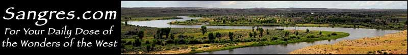
Crossing over the southern part of the Big Horn Mountains on US 16 (the Cloud Peak Skyway), you'll leave Bighorn National Forest and then enter Nowood Valley. Ten Sleep is in the bottom of Nowood Valley near the confluence of Ten Sleep and Nowood Creeks. If you're in this area on July 4th, you might want to check out the world famous 4th of July Parade and Rodeo: Ten Sleep hasn't missed this one since 1946.
The Girl Scouts National Center West is just outside of Ten Sleep, near the entrance to Ten Sleep Canyon. This is a 15,000-acre site with campgrounds and facilities for workshops and seminars.
Latitude: 44.0347°N
Longitude: 107.448°W
Elevation: 4,426'
Education:
High School or Higher: 89.8%
Bachelor's Degree or Higher: 15.1%
Graduate or Professional Degree: 1.8%
2011 Cost of Living Index for Ten Sleep: 81.0
Estimated Median Household Income: $34,200
Estimated Median Home Value: $129,500
Median Resident Age: 48.0 Years
Major Industries:
Lodging & Food Services, Mining, Educational Services, Health Care, Construction, Agriculture, Arts & Entertainment, Retail Services, Light Manufacturing
Unemployed (March 2011): 7.0%
Population Demographics: 2010
| Total Population | 260 |
| Males | 140 |
| Females | 120 |
| Population by Age | |
| Under 18 | 45 |
| 18 & over | 215 |
| 20-24 | 7 |
| 25-34 | 27 |
| 35-49 | 40 |
| 50-64 | 67 |
| 65 & over | 74 |
| Population by Ethnicity | |
| Hispanic or Latino | 2 |
| Non Hispanic or Latino | 258 |
| Population by Race | |
| White | 253 |
| African-American | 0 |
| Asian | 1 |
| Native American | 2 |
| Hawaiian or Pacific Islander | 0 |
| Other | 0 |
| Two or more | 4 |
