
Byers Peak Wilderness
The 8,913-acre Byers Peak Wilderness was established by Congress in 1993. The property is entirely within the boundaries of Arapaho-Roosevelt National Forest in Grand County, but is actually part of a 100,000-acre roadless complex (with Vasquez Peak Wilderness on its southern boundary with the Williams Fork-Ptarmigan Peak roadless area south of that). Byers Peak was named after William N. Byers, founder of Colorado's first newspaper - the still-published Rocky Mountain News. He was also the first mayor of Hot Sulphur Springs.
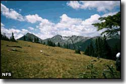
With eco-zones ranging from low-lying lodgepole pine forest and riparian drainages to alpine tundra over 12,000 feet in elevation, the landscape and environment at Byers Peak Wilderness is typical of high-country Colorado. About 1/2 of Byers Peak Wilderness is purely alpine tundra on landscape above treeline. Along with this variety of vegetation and climate comes a wide variety of flora and fauna. On any given day you can see deer, elk, bear, mountain goats, bighorn sheep, the occasional moose, ptarmigan, marmots, and several species of trout and small rodents. You'll also find two glacial lakes, three major creek drainages and two peaks over 12,500 feet (the highest being Byers Peak at 12,804 feet) on the property.
The Byers Peak Trail crosses the Wilderness from Bottle Pass to St. Louis Peak (north to south) and almost never comes below treeline (meaning: expect no shade trees along the route). The Wilderness does contain some 23 miles of trails with some of the finest ridge trekking in the state. Great panoramic views, several scenic lakes... and all in a small and obscure wilderness in the Rocky Mountains of Colorado.

Byers Peak Wilderness map
Selected Hiking Trails
National Park Service Sites - BLM Sites - National Wilderness Areas - Unique Natural Features
Outdoor Sports & Recreation - Ski & Snowboard Areas - Photo Galleries - Colorado Mountains
