 |
Minidoka National Wildlife Refuge |
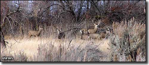 Mule deer at Minidoka NWR |
|
Minidoka National Wildlife Refuge is centered around Lake Walcott in the Snake River Plain, about 12 miles northeast of the town of Rupert. The refuge stretches about 25 miles upstream from Minidoka Dam with maybe 80 miles of shoreline around the lake, encompassing some 20,699 acres. About half the property is open water and wetlands, the other half is low, rolling uplands with scattered outcroppings of basalt among sagebrush, native grasses and small stands of juniper. The wetlands has a lot of bulrush marsh and cattail habitat around the bays of the lake. Almost rimming the whole shoreline are stands of cottonwood, willows and other trees. This is a large refuge that can see upwards of 100,000 birds in the late summer and early fall migration season along the Pacific Flyway. Among the regular visitors to Minidoka: mallards, Canada geese, redhead, pintails, wigeons and gadwalls. A lot of these birds come to Lake Walcott to molt in July, August and September. More than 230 species of birds have been documented at Minidoka National Wildlife Refuge and the refuge is a designated Bird Area of Global Importance. Minidoka NWR is also a regular wintering spot for bald eagles. There are nesting colonies of Clark's and western grebe, great blue heron, double-crested cormorant, black-crowned night heron, snowy egret, California gull, American white pelican and the odd cattle egret or great egret. During season, a lot of nesting areas at Minidoka NWR are closed to the public so as not to disturb nesting birds. More than 500 tundra swans also visit the refuge during the spring and fall migrations. Beneath much of the open water of the reservoir are shallow beds of submergent aquatic vegetation. The water tends to be warm and supports the growth of "trash" fish. The vegetation and fish attract colonial nesting bird species. The fish also support a healthy population of mink and river otters. Among the year-round inhabitants of the area you'll find mule deer, pronghorn, beaver, muskrat, raccoon, striped skunk, coyote, cottontail, porcupine, ring-necked pheasant, gray partridge and sage and sharp-tailed grouse. More rare are elk, moose, bobcat and cougar. The Utah valvata, an endangered snail, lives in the reservoir. You might also find a species of special concern, the Idaho dunes tiger beetle, hanging out in the refuge sand dunes area. This is a semi-arid climate with most of its precipitation arriving as snow. Summers are hot and dry with a thunderstorm season and heavy rains. Winters aren't too cold but they tend to be windy. Elevation: 4,200'. Construction of Minidoka Dam on the Snake River began in 1904. The main reason for building the dam was to provide water for irrgation purposes and to provide hydroelectric power for the area. While the reservoir was still filling, the area began attracting large numbers of migratory birds and other wildllife. In 1909, President Theodore Roosevelt ordered the creation of Minidoka National Wildlife Refuge as one of the very first in a series of national wildlife refuges. He created these National Wildlife Refuges using executive order, stating that is was important to set aside refuges like these as "preserves and breeding grounds for native birds." Over the years, Presidents Taft, Hoover and Roosevelt added more land to Minidoka and increased the number of names on the list of protected wildlife welcome here. For human visitors the refuge offers access to water activities on the reservoir. Sensitive areas are closed to boating but many folks come for the fishing. Limited hunting is allowed in season and in designated areas only. Camping and campfires are allowed at Lake Walcott State Park, wholly enclosed within Minidoka National Wildlife Refuge (near Minidoka Dam). For hikers there is a short paved trail near the entrance with another graveled trail on the east side of the boat ramp. Most of the land area of the refuge is open to hiking but there are no marked or maintained trails. The refuge is open to the public from sunrise to sunset daily but the office tends to be closed when personnel are in the field. To get there: from Rupert follow Idaho Highway 24 northeast. In Rupert you'll need to watch the signs closely because it's not a straight route. About 5.5 miles northeast of Rupert you'll turn right on the Minidoka Dam Road and follow that into the refuge. From Interstate 86 there are a couple options. From the Raft River exit (exit 15) you can follow the signs on the north side of the Interstate to the boat ramp at Gifford Springs. Or you can exit at Cold Water (exit 21) and take the gravel road on the north side of the Interstate to the refuge entrance. There's another route to the refuge from Old Highway 30 on the south side of the reservoir. |
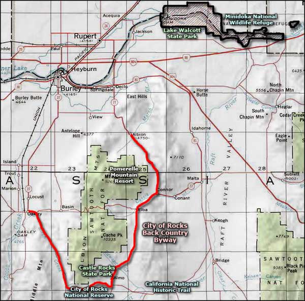 Minidoka National Wildlife Refuge area map |
|
|
 |
| Index - Arizona - Colorado - Idaho - Montana - Nevada - New Mexico - Utah - Wyoming National Forests - National Parks - Scenic Byways - Ski & Snowboard Areas - BLM Sites Wilderness Areas - National Wildlife Refuges - National Trails - Rural Life Advertise With Us - About This Site - Privacy Policy |
| Photo of mule deer at Minidoka NWR courtesy of US Fish & Wildlife Service. Area map courtesy of National Geographic Topo! Text Copyright © by Sangres.com. All rights reserved. |