 |
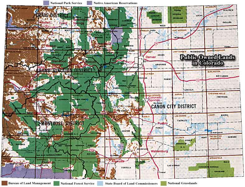
Map Showing Public Owned Lands in Colorado |

|
|
You can see from the above map that west of the I-25 there is a severe shortage of private land. The checkerboard pattern in the eastern plains is the result of two sections of each township being designated "School Land" and given to the State Board of Land Commissioners. Most of the BLM and the School Land properties are leased for agriculture (cattle grazing). Approximately 450,000 acres of School Land is leased by the Colorado Division of Wildlife for seasonal hunting purposes. |
Colorado Pages
Towns & Places - Scenic Byways - State Parks - BLM Sites - History & Heritage Ski & Snowboard Areas - Photo Galleries - Colorado Mountains - Scenic Railroads Unique Natural Features - Wilderness Areas - Outdoor Sports & Recreation Colorado's National Forests - National Wildlife Refuges - Colorado's National Parks |

|
| Index - Arizona - Colorado - Idaho - Montana - Nevada - New Mexico - Utah - Wyoming National Forests - National Parks - Scenic Byways - Ski & Snowboard Areas - BLM Sites Wilderness Areas - National Wildlife Refuges - National Trails - Rural Life Advertise With Us - About This Site - Privacy Policy |
|
Text Copyright © by Sangres.com. All rights reserved. |