 |
Pompey's Pillar National Monument |
 Pompey's Pillar |
|
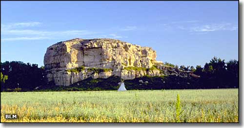
In 1805, as William Clark was heading back east from the Lewis & Clark Expedition of Discovery to the Pacific Ocean, his group came across Pompey's Pillar on the shores of the Yellowstone River. They stopped and hung out for a bit. In his journal, William Clark wrote of climbing the rock and enjoying "a most extensive view in every direction on the Northerly Side of the river high romantic Clifts approach & jut over the water for Some distance both above and below...I marked my name and the day of the month and year." This is the site of the only physical evidence that the "Corps of Discovery" actually passed this way in their journey. Clark named the rock "Pomp's Tower," after his nickname for the infant son of Sacajawea (who had actually been named Jean Baptiste Charbonneau). "Pompy" is a Shoshoni word for "little chief." When Nicholas Biddle published an account of the expedition in 1814 he changed the name of the rock to "Pompey's Pillar," and that's the name that has stuck ever since. Geologically speaking, Pompey's Pillar is a large chunk of the Hell Creek Formation, sandstones and shales deposited during the Upper Cretaceous Period, 75 to 65 million years ago (at the end of the Age of Dinosaurs). Clark's journal records his discovery, immediately downstream from Pompey's Pillar, of "the rib of a fish which was Semented within the face of the rock. ...it is 3 feet in length tho a part of the end appears to have been broken off." As the most common dinosaurs of that size in this area at that prehistoric time were triceratops, tyrannosaurus, albertosaurus and hadrasaurus, he might have discovered a bone from one of those. William Clark isn't the only "grafitti artist" recorded by Pompey's Pillar: there are more than 5,000 drawings and etchings on the rock left by early fur trappers, railroad workers, military expeditions and early passing settlers. For many years, the Yellowstone River was a major traffic corridor, carrying mineral prospectors and homesteaders into southwestern Montana. In 1873, the 3rd transcontinental railroad survey expedition made its way through the area and camped at the mouth of Pompey's Pillar Creek, just across the Yellowstone from the monument itself. They were accompanied by 10 companies of the 7th Cavalry under the command of Lieutenant Colonel George Armstrong Custer. On the morning of March 16, 1873, they were fired on by a group of Natve Americans who had worked their way into the brush at the foot of Pompey's Pillar during the night. A steamboat captain named Grant Marsh was the first to raise an American flag on the top of Pompey's Pillar, in 1875. The Northern Pacific Railroad was completed through the Yellowstone River Valley in 1882 and the Pompey's Pillar Station was established about 1/2 mile below the pillar. So many train passengers were getting off to visit the site of Clark's signature that the Northern Pacific Railroad covered the signature area with a heavy iron screen to protect it. By that time, treaty had given most of the Yellowstone River Valley to the Crow Nation, but a little politicking and lots of newspaper editorials convinced the federal government that the agricultural value of the Valley was being wasted on the Crows. So Congress passed legislation that forced the Crow Nation to cede the land to the Government Land Office, which then sold the land to settlers and land speculators. The area finally started to see homesteaders moving in in the early 1900's. Pompey's Pillar was designated a National Historic Landmark in 1965 and came to be owned by the Bureau of Land Management in 1991. The site was declared a National Monument in 2001. When the Monument is open for drive-in visitation, a $7 entrance fee is charged for each vehicle (except for commercial and group visits, which fees are based on vehicle capacity). From late April to late May you can pass through the gates and drive up to the parking area, interpretive center, restrooms and day use area from 9 AM to 5 PM daily. From late May to early September, the gates are open daily from 8 AM to 8 PM. From early September to late October, the gates are open from 9 AM to 4 PM every day. The rest of the year you can make the 3/4 mile walk from the gates to the pillar at any time during daylight hours for free. There is a 1,000-foot-long boardwalk that climbs past Clark's signature and leads to the top of the pillar. It is probably the only human-made installation on the property that is not fully accessible. |
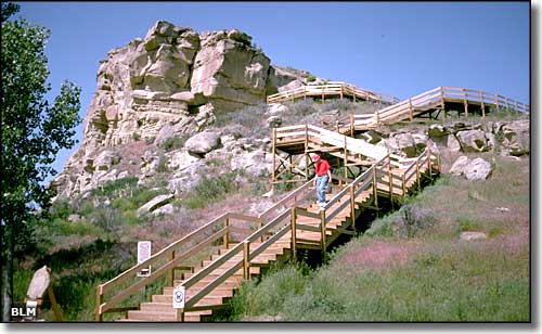 The stairway leading to the signature area and the top of Pompey's Pillar 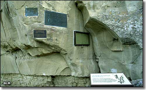 Commemorative plaques and the glass frame protecting William Clark's signature on Pompey's Pillar 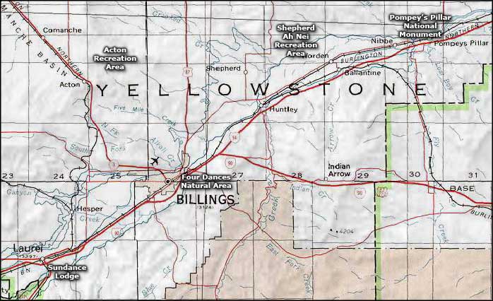 Pompey's Pillar National Monument area map |
|
|
 |
| Index - Arizona - Colorado - Idaho - Montana - Nevada - New Mexico - Utah - Wyoming National Forests - National Parks - Scenic Byways - Ski & Snowboard Areas - BLM Sites Wilderness Areas - National Wildlife Refuges - National Trails - Rural Life Advertise With Us - About This Site - Privacy Policy |
| Photos of Pompey's Pillar National Monument courtesy of the Bureau of Land Management Map courtesy of National Geographic Topo! Text Copyright © by Sangres.com. All rights reserved. |