 |
Baker, Montana |
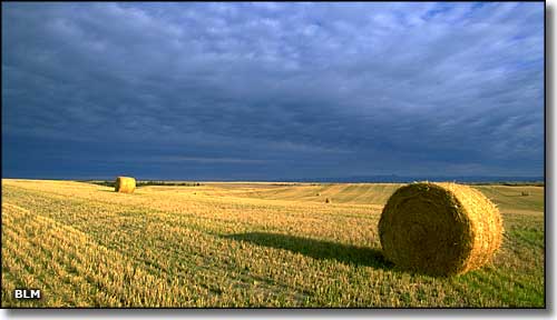 A typical view in the Baker area |
|
Baker is located in the southeastern plains region of Montana. The Chicago, Milwaukee, St. Paul and Pacific Railroad had dammed Sandstone Creek and built a lake in the area to supply water for its locomotives. The original settlement on the lakeshore was named Lorraine but that was changed to Baker (after A.G. Baker, an engineer who worked for the railroad) when the town was incorporated in 1908. The Milwaukee Land Company (a fully-owned subsidiary of the railroad) was quite successful in attracting homesteaders to the area after that. Oil and natural gas were discovered close by in 1912. Baker became a center for dryland farming and the population passed 1,000 people by 1920. The population continued to rise slowly until it peaked at just over 2,500 in 1970, then started to dwindle. The railroad is now the Burlington Northern-Santa Fe and Baker is at the crossroads of US Highway 12 and Montana State Road 7. |
| Fast Facts about Baker, Montana |
|
Baker, Fallon County, MT 59313
Incorporated: 1908 Elevation: 2,936' Latitude: 46.3648°N Longitude: 104.2751°W Resident Racial Breakdown: White Non-Hispanic: 97.8% Hispanic: 0.3% Two or more races: 0.5% Asian: 1.3% Education: High School or Higher: 84.7% Bachelor's Degree or Higher: 14.4% Graduate or Professional Degree: 5.0%
2009 Estimates: Population: 1,640 Males: 807 Females: 833 Median Resident Age: 40.3 Years Estimated Median Household Income: $46,500 Estimated Median Home Value: $88,500 Population Density: 1,911 People per Square Mile 2011 Cost of Living Index for Baker: 85.2 Major Industries: Health Care, Oil & Gas Extraction, Educational Services, Construction, Agriculture, Lodging & Food Services, Transportation Services, Government, Food Stores, Finance & Insurance Services Unemployed (March 2011): 2.7% |
|
|
 |
| Index - Arizona - Colorado - Idaho - Montana - Nevada - New Mexico - Utah - Wyoming National Forests - National Parks - Scenic Byways - Ski & Snowboard Areas - BLM Sites Wilderness Areas - National Wildlife Refuges - National Trails - Rural Life Advertise With Us - About This Site - Privacy Policy |
| Photo courtesy of the Bureau of Land Management Text Copyright © by Sangres.com. All rights reserved. |