 |
Beartooth Highway |
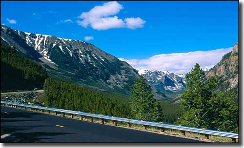 The Beartooth Highway in Rock Creek Canyon, southwest of Red Lodge, Montana |
|
The Beartooth Highway is composed of US Highway 212 between Red Lodge, Montana and the northeastern entrance to Yellowstone National Park near Cooke City, Montana. In winter, the stretch of road between Red Lodge and the intersection with Wyoming Highway 296 (the Chief Joseph Scenic Byway) is closed by snow. But when this road is open, as Charles Kurault once said, this is "America's most beautiful highway." Wildflower-filled alpine meadows, high mountain glaciers and the rugged mountainscape of the Beartooth and Absaroka Ranges. And then you arrive at Yellowstone... I'm sure Native Americans and early French, British and American fur trappers and mountain men crossed this area for years, but the first pioneer to make the journey and mark the route taken was General Sherman in 1882. The Beartooth Highway itself wasn't built until 1936, but since the route was opened, millions of folks have traveled this road and enjoyed the views, the wildlife and the drive through lush green forest into alpine tundra. In places along the way you'll have the Absaroka-Beartooth Wilderness to the north and the North Absaroka Wilderness to the south. This is some of America's wildest and most pristine countryside. There are several campgrounds along this route, spread through three National Forests: the Custer, Shoshone and Gallatin. As this highway sees lots of traffic (and campers) in season, you might want to check out making reservations in advance of your trip through here. You'll find data under the road map below. |
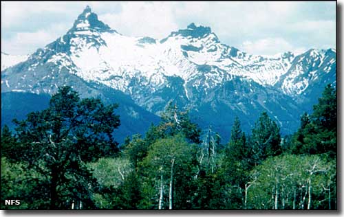 Pilot and Index Peaks from near Cooke City, Montana 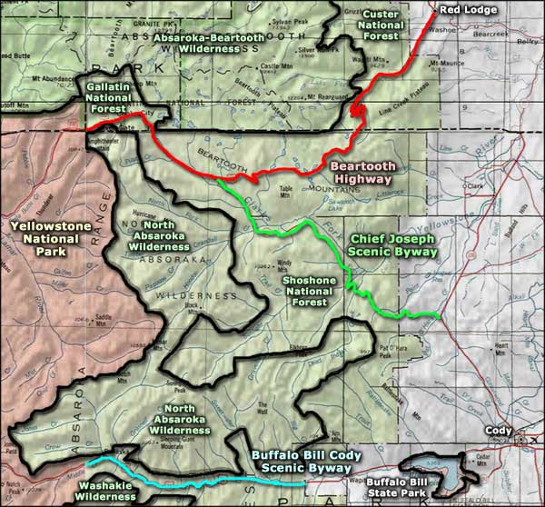 Beartooth Highway area map |
| Campgrounds Along the Beartooth Highway - US Highway 212 Starting at Red Lodge, MT going into Wyoming and ending at Cooke City, MT at the NE Entrance to Yellowstone National Park |
| Custer National Forest |
|
Campground |
# of Units |
Max. Trailer Length |
Season |
Elevation |
Campground Host or Concessionaire |
Comments |
||
|---|---|---|---|---|---|---|---|---|
|
Sheridan - 6 mi S. of Red Lodge (reservable) |
8 |
30' |
May to Sept |
6,300' |
Concessionaire |
1 hand pump |
$12 |
There is a charge of $8 per additional vehicle. Day use fee of $6 over 1/2 hr. |
|
Rattin - 8 mi S. of Red Lodge (reservable) |
6 |
25' |
May to Sept |
6,400' |
Concessionaire |
1 hand pump |
$12 |
There is a charge of $8 per additional vehicle. Day use fee of $6 over 1/2 hr. |
|
Parkside - 12 mi S. of Red Lodge (reservable) |
28 |
45' |
May to Sept |
7,300' |
Concessionaire |
2 hand pumps |
$12 |
There is a charge of $8 per additional vehicle. Day use fee of $6 over 1/2 hr. |
|
Limber Pine - 12 mi S. of Red Lodge (reservable) |
13 |
45' |
May to Sept |
7,200' |
Concessionaire |
1 hand pump |
$12 |
There is a charge of $8 per additional vehicle. Day use fee of $6 over 1/2 hr. |
| Greenough Lake - 12 mi S. of Red Lodge (reservable) |
18 |
50' |
May to Sept |
7,300' |
Concessionaire |
1 hand pump |
$12 |
There is a charge of $8 per additional vehicle. Day use fee of $6 over 1/2 hr. |
| M-K - 12 mi S. of Red Lodge |
10 |
22' |
May to Sept |
7,500' |
- |
- |
- |
No services. Fishing and hiking nearby. |
| Shoshone National Forest |
|
Campground |
# of Units |
Max. Trailer Length |
Season |
Elevation |
Campground Host or Concessionaire |
Comments |
||
|---|---|---|---|---|---|---|---|---|
|
Island Lake - 29 mi S. of Red Lodge |
20 |
32' |
July to mid-Sept |
9,600' |
Campground Host |
- |
$10 |
Boat ramp, fishing, trailhead, wilderness access, store nearby |
|
Beartooth Lake - 31 mi S. of Red Lodge |
20 |
32' |
July to mid-Sept |
9,000' |
Campground Host |
2 hand pumps |
$15 |
Boat ramp, fishing, trailhead, store nearby, picnic area |
|
Crazy Creek - 11 mi E. of Cooke City |
16 |
32' |
May to Sept |
6,900' |
Campground Host |
- |
$10 |
Stream fishing nearby, trailhead, scenic walk to waterfall |
|
Fox Creek - 7 mi E. of Cooke City |
27 |
50' |
May to Sept |
7,100' |
Campground Host |
X |
$20 |
Water and power hookups at sites. Double and triple sites available |
| Gallatin National Forest |
|
Campground |
# of Units |
Max. Trailer Length |
Season |
Elevation |
Campground Host or Concessionaire |
Comments |
||
|---|---|---|---|---|---|---|---|---|
|
Chief Joseph - 4 mi E. of Cooke City |
6 |
42' |
Mid-June to end of Sept |
7,400' |
- |
X |
$8 |
$3 charge per additional vehicle. |
|
Colter - 2 mi E. of Cooke City |
23 |
32' |
Closed |
7,400' |
- |
X |
$8 |
|
|
Soda Butte - 1 mi E of Cooke City |
21 |
48' |
July to mid-Sept |
7,400' |
- |
X |
$9 |
$3 charge per additional vehicle |
|
|
Beartooth Highway Related Pages
Custer National Forest - Gallatin National Forest - Shoshone National Forest
Yellowstone National Park - Absaroka-Beartooth Wilderness - North Absaroka Wilderness Washakie Wilderness - Chief Joseph Scenic Highway - Buffalo Bill Cody Scenic Byway Buffalo Bill State Park - Beartooth Highway-Wyoming Montana Pages |
 |
| Index - Arizona - Colorado - Idaho - Montana - Nevada - New Mexico - Utah - Wyoming National Forests - National Parks - Scenic Byways - Ski & Snowboard Areas - BLM Sites Wilderness Areas - National Wildlife Refuges - National Trails - Rural Life Advertise With Us - About This Site - Privacy Policy |
| Upper photo of Rock Creek Canyon on the Beartooth Highway courtesy of Travel Montana, via Byways.org Photo of Pilot and Index Peaks courtesy of the National Forest Service Map courtesy of National Geographic Topo! Text Copyright © by Sangres.com. All rights reserved. |