 |
Sheldon National Wildlife Refuge |
|
|
 Sheldon National Wildlife Refuge |
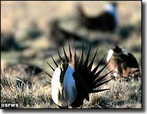
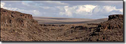
Sheldon National Wildlife Refuge is a 575,000-acre property against (and actually spilling over a bit) the Oregon border in northwestern Nevada. This is an arid, high desert zone to the north of the Black Rock Desert-High Rock Canyon Emigrant Trails National Conservation Area with lots of volcanic terrain. The Refuge was originally set aside in 1936 as the Charles Sheldon Antelope Range. There are still about 3,500 pronghorn "antelope" on the property but there are also large herds of mule deer, a self-sustaining population of bighorn sheep and several herds of wild horses. With elevations ranging from 4,100' to 7,200', the dominant flora here are drought-tolerant plants like aspen, bitterbrush, juniper, sagebrush and mountain mahogany. In the late 19th and early 20th centuries, the area was homesteaded by folks who didn't realize how marginal the opportunity for human habitation was. So you'll find old homesteads and ranches scattered around this vast and rugged countryside. The Virgin Valley mining district is where you might find some fire opals and other gems. There's a few mineral hot springs, some waterfalls, narrow gorges and lush stream valleys, too. The best time to come and watch for pronghorns is in the fall and winter when they gather into large herds. In spring and summer they scatter across the landscape in small groups and are much harder to find. In late summer and fall they collect near the greenery around Swan Lake, then they tend to spend their winters on Big Springs Table. On the rocky walls above Hell Creek, Thousand Creek and the IXL Ranch, and near the west approach to Little Sheldon you might be able to see some of the small herd of reintroduced California bighorn sheep. Still, you're liable to find more ancient petroglyphs of bighorn sheep than actual living sheep. In the flatter but higher reaches of Sheldon National Wildlife Refuge you'll probably see lots of mule deer. You can also catch a view of mule deer when they come down to Little Sheldon and Catnip Reservoir for a drink. You can usually find sage grouse in the sparsely-covered hills and valleys along the road between Last Chance Ranch and Catnip Reservoir. The best way to see them is from your vehicle and the best time is in the spring when the males are strutting and thumping their air sacs during their elaborate courtship dances. Catnip Reservoir, Big Springs Reservoir, Swan Lake, Dufurrena Ponds and the wetlands around the IXL Ranch are managed to attract all kinds of waterfowl, including American white pelicans and Canada geese. These days you'll also find feral burros and horses roaming all over the Refuge. The most common sightings occur along Highway 140 East. Burros are usually seen throughout the Virgin Valley and in the flats east of Thousand Creek. Wild horses congregate in the valleys between the Catnip and Badger Mountains, using the water holes and mucking up the stream sides. Most fishing spots at Sheldon National Wildlife Refuge don't allow motorized boats. Catnip Reservoir is catch-and-release only and is open for fishing from September 1 through November 15. Big Springs Reservoir is open for fishing year round and the rainbow and cutthroat trout are always biting. The Dufurrena Ponds offer warm water fish like bass and crappie. The designated fishing hole at the Virgin Valley Campground is for children and seniors only. There is a very limited amount of hunting allowed for deer, bighorn sheep and pronghorns, and all tags are draw only. All hunting, including bird hunting, requires a Nevada hunting license. Hunting for sage grouse requires a special permit from NDOW. There is no waterfowl hunting allowed in the Dufurrena Ponds area or at Little Sheldon, Big Spring Reservoir or Catnip Reservoir. There is no hunting allowed in the Virgin Valley either, and target shooting is not allowed anywhere. Camping is allowed only in designated places. The most comfortable spot is the Virgin Valley Campground where you'll find pit toilets, drinking water, picnic tables, a rustic shower house and a warm springs pool. All other camps are more primitive, only a few have pit toilets and none have potable water. A backpacking permit is required for backpacking, especially if you intend to camp anywhere along your route (the permit is free, just get one from the Refuge Manager). The refuge stay limit is 14 days. Charcoal barbecues and campfires are only allowed during times of low fire danger, and for a campfire you'll need to bring your own firewood anyway. Propane stoves are allowed, except in times of high fire restriction. Horses are allowed but you'll need to bring pelletized feed. Corrals are available at Fish Creek and Badger Camp. Rock hounds: the Virgin Valley Mining District covers 67,000 acres and has many mining claims on it, including patented claims. Some allow you to collect for a fee but all require permission. Outside the Virgin Valley District, you can surface collect (no digging) up to seven pounds of rocks for personal use per day. The big deal here is the Virgin Valley fire opal, although some beautiful samples of black opal have been found here, too. The easiest access to the heart of Sheldon NWR is via Highway 140: go 68 miles east from Lakeview, OR. Or you can go to Denio, NV on SR 142 and take a left on SR 140, go 14 miles to the eastern edge of Sheldon NWR. Gas and groceries are at Lakeview, Denio or 100 miles south at Winnemucca. The Royal Peacock Mine in Virgin Valley offers some supplies, a pay phone and several furnished overnight accommodations, but only in summer. Off-road driving is not allowed. Keep all mechanized vehicles (including bikes) on the designated roads. Most refuge roads are maintained just well enough to accommodate high clearance 4WD, but all bets are off if it gets wet. Forget your cell phone, forget emergency services, forget roadside assistance: out here you're on your own. |
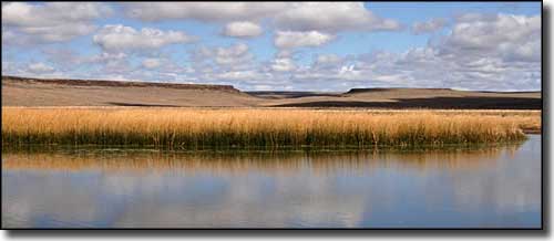 Ponds in the Virgin Valley 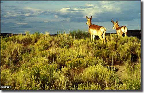 Pronghorns at Sheldon NWR 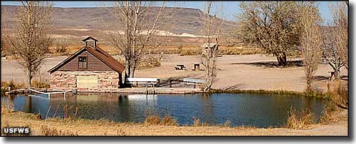 Virgin Valley Campground 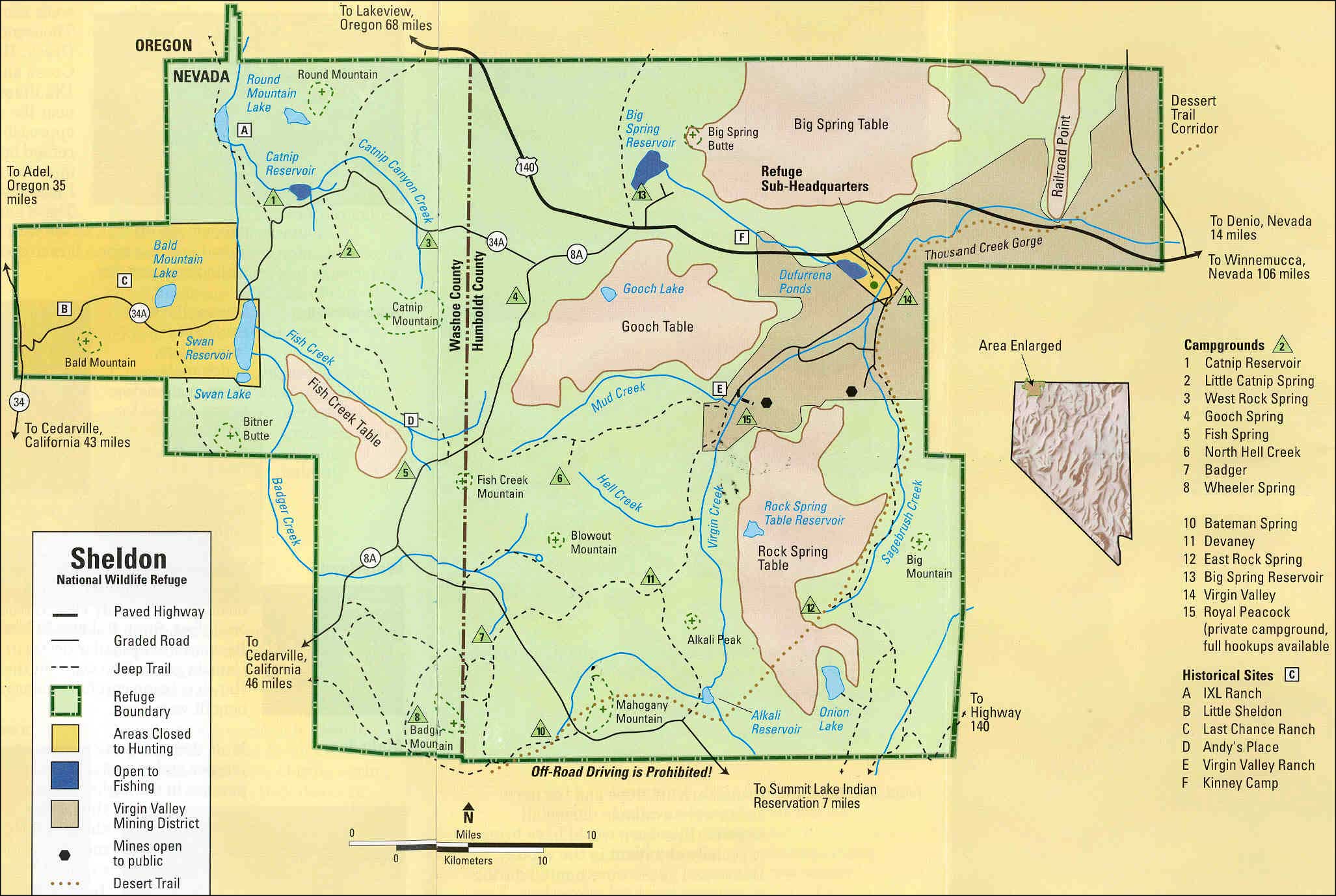 Sheldon National Wildlife Refuge area map Click on the map for a larger version. |
|
|

|
| Index - Arizona - Colorado - Idaho - Montana - Nevada - New Mexico - Utah - Wyoming National Forests - National Parks - Scenic Byways - Ski & Snowboard Areas - BLM Sites Wilderness Areas - National Wildlife Refuges - National Trails - Rural Life Advertise With Us - About This Site - Privacy Policy |
| Some photos of Sheldon NWR courtesy of Marilyn Gregory, US Fish & Wildlife Service. Other photos and map courtesy of the US Fish & Wildlife Service Text Copyright © by Sangres.com. All rights reserved. |