 |
|---|
Selected Hiking Trails in Colorado |
|
|
 |
|
Two long-distance hiking trails of national importance pass through southern Colorado: the Colorado Trail and the Continental Divide National Scenic Trail. The Colorado Trail is a 469 mile trail between Denver and Durango. The 3,100 mile Continental Divide Trail is proposed between the Mexican and Canadian borders. Numerous side trails connect these two trails with campgrounds, trailheads and local communities along the way. |
|
The Colorado Trail is open to hikers, horseback riders and cross-country skiers. Mountain bikes are currently permitted on the non-Wilderness segments of the trail. The trail passes through seven National Forests, six Wildernesses, five major river systems, and eight mountain ranges. The trail is even more impressive because it was created through a massive volunteer effort involving thousands of trail-building enthusiasts. The Colorado Trail is jointly administered by the Colorado Trail Foundation and the US Forest Service. The 3,100 mile Continental Divide National Scenic Trail, when completed, will provide spectacular backcountry travel the length of the Rocky Mountains from Mexico to Canada. It is the most rugged of the long distance trails. The trail was designated in 1978 and is designed to be an educational as well as a hiking experience. The trail traverses a variety of terrain, including high desert, forests, geologic formations, and mountain meadows. Along the way travelers can catch glimpses of a variety of historical, cultural and scenic landscapes, as well as abundant wildlife. Hiking opportunities range from short leisurely hikes to challenging alpine and desert segments. |
|
The BLM Lands and the National Forests of Colorado are also full of hiking trails. Some of them are old mining or logging roads, others are jeep trails. It seems that both the BLM and the Forest Service have a no-maintenance policy in effect when it comes to roads. There are some roads that see a lot of travel that are well taken care of, there are others that haven't been touched in many a summer. There's good and bad to this. If the road has been gated, chances are good that you won't run into any vehicular traffic on your hike. If the road is not gated, you're taking your chances in terms of running into vehicles along the way (see On 4WD Vehicles in the Wilderness). On the other hand, some of these old roads are now just trails that fade in and out of the wilderness as you travel them. In some respects, they make it easier to get where you want to go without impacting the countryside or the scenery any more heavily than it is already hit. |
| Selected Hiking Trails |
|
Barr National Recreation Trail (TR 620) - Pike National Forest - 11.7 miles Bear Creek National Recreation Trail (TR 241) - Uncompahgre National Forest - 7 miles Braille Trail - White River National Forest - 0.25 miles Byer's Peak Trail (TR 15) - Arapaho-Roosevelt National Forest - 2.4 miles Climbing Mt. Harvard - San Isabel National Forest - 8.5 miles Colorado Trail - Kassler - 470 miles Columbine Lake Trail (TR 11) - Arapaho-Roosevelt National Forest - 2.8 miles Continental Divide National Scenic Trail - Routt National Forest - 600 mile route Conundrum Trail (TR 1981) - White River National Forest - 13 miles Crag Crest National Recreation Trail (TR 711) - Grand Mesa National Forest - 10 mile loop Curecanti Creek Trail - Curecanti National Recreation Area - 2 miles Devil's Head National Recreation Trail (TR 611) - Pike National Forest - 1.3 miles East Bellows Creek Trail (TR 790) - Rio Grande National Forest - 8 miles Fish Creek Trail (TR 1102) - Routt National Forest - 10.5 miles Fourmile Falls Trail (TR 579) - San Juan National Forest - 3 miles Greyrock National Recreation Trail (TR 946) Arapaho-Roosevelt National Forest - 3.5 miles Hanging Lake Trail (TR 1850) - White River National Forest - 1.2 miles Harper's Corner Nature Trail - Dinosaur National Monument - 1 mile Herman Gulch Trail (TR 98) - Arapaho-Roosevelt National Forest - 2.5 miles Hermosa Creek Trail (TR 514) - San Juan National Forest - 20 miles Main Dune Mass Climb - Great Sand Dunes National Park - various routes Mill-Castle Trail (TR 450) - Gunnison National Forest - 14.3 miles Monument Canyon Trail - Colorado National Monument - 6 miles Mosca Pass Trail - Great Sand Dunes National Park - 3.5 miles Mt. Garfield Trail - BLM Grand Junction Recreation Management Area - 2 miles Neversink Trail - Curecanti National Recreation Area - 0.5 miles North Chasm View Trail - Black Canyon of the Gunnison National Park - 0.7 mile loop North Vista Trail - Black Canyon of the Gunnison National Park - 3.5 miles Oak Flat Trail - Black Canyon of the Gunnison National Park - 1.5 mile loop Overlook Trail (TR 641) - Pike National Forest - 0.5 mile Pawnee Buttes Trail (TR 840) - Pawnee National Grasslands - 2 miles Petroglyph Point Trail - Mesa Verde National Park - 2.8 mile loop Prater Ridge Trail - Mesa Verde National Park - 7.8 mile loop Rabbit Valley Interpretive Trail - BLM Grand Junction Recreation Area - 1.5 mile loop Rainbow Trail - San Isabel National Forest - 100 miles Round Mountain National Recreation Trail (TR 831) - Arapaho-Roosevelt National Forest - 4.5 miles Serpent's Trail - Colorado National Monument - 2.3 miles South Mt. Elbert Trail (TR 1481) - San Isabel National Forest - 6 miles Uncompahgre Peak Trail (TR 239) - Uncompahgre National Forest - 5 miles Wager Gulch Trail - BLM Gunnison Recreation Area - 4.8 miles West Lost Trail (TR 822) - Rio Grande National Forest - 6.1 miles |
| Rocky Mountain National Park |
|
Black Lake Trail - 4.7 miles Cascade Falls Trail - 3.5 miles Dream Lake Trail - 1.1 miles East Longs Peak Trail - 8 miles Eugenia Mine Trail - 1.4 miles Fern Lake Trail - 8.5 miles Lawn Lake Trail - 6.2 miles Lulu City Trail - 3.1 miles North Longs Peak Trail - 9.5 miles Ouzel Falls Trail - 2.7 miles Timber Lake Trail - 4.8 miles |
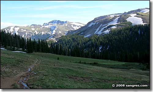
 Matterhorn Trail, Uncompahgre Wilderness |
Related Pages
Arapaho-Roosevelt National Forest Trails - Rio Grande National Forest Trails
San Isabel National Forest Trails - Pike National Forest Trails Colorado Pages
Towns & Places - Scenic Byways - State Parks - BLM Sites - History & Heritage Ski & Snowboard Areas - Photo Galleries - Colorado Mountains - Scenic Railroads Unique Natural Features - Wilderness Areas - Outdoor Sports & Recreation Colorado's National Forests - National Wildlife Refuges - Colorado's National Parks |
 |
| Index - Arizona - Colorado - Idaho - Montana - Nevada - New Mexico - Utah - Wyoming National Forests - National Parks - Scenic Byways - Ski & Snowboard Areas - BLM Sites Wilderness Areas - National Wildlife Refuges - National Trails - Rural Life Advertise With Us - About This Site - Privacy Policy |
| Photos courtesy of Sangres.com, CCA ShareAlike 3.0 License. All text Copyright © by Sangres.com. All rights reserved. |