Bighorn Scenic Byway

A typical view on the western slopes of the Bighorn Mountains along the Bighorn Scenic Byway

The Bighorn Scenic Byway follows US Highway 14 for about 47 miles across Bighorn National Forest between Shell and Ranchester, Wyoming. About halfway across this northern end of the Big Horn Mountains, the Bighorn Scenic Byway meets the Medicine Wheel Passage Scenic Byway at Burgess Junction.
Starting in the town of Shell, Wyoming, the Byway ascends into the Big Horn Mountains via Shell Canyon. Shell Canyon got the name because of all the fossilized sea shells in the sandstone outcroppings in this area. That sandstone dates at about 550 million years old, while the granite it sits on goes back about 3 billion years. Not too far in you'll see the turnoff to Shell Falls where you can get up close to the water or hike around the interpretive trail a bit. At a flow of 3,600 gallons per minute, you can feel the water thundering through the falls. From Shell Falls, the highway uses several switchbacks to climb the mountains until it finally levels out (sort of) near Antelope Butte Ski Area. The road continues northeast to Granite Pass (9,033') and then to Burgess Junction.
There's a Visitor Center at Burgess Junction you might want to stop and visit with: interpretive trail, exhibits, info, theater and rest rooms... Then the Byway continues east across the Big Horns and offers some pretty spectacular views down the hill over the Sheridan Valley and the Tongue River Canyon.
Coming down into Ranchester, just beyond the end of the Byway, is the Connor Battlefield State Historic Park, commemorating the Battle of Tongue River, fought in 1865 between General P.E. Connor and his 400 men and a village of about 500 Arapahos they had attacked. Their objective was to reduce the ability of the Sioux, Cheyenne and Arapaho tribes to conduct raids against the old wagon routes and the overland mail routes. The Tongue River Battle was no big deal but it was the lone major engagement of the Powder River Expedition. It wasn't that the soldiers killed or captured all that many Indians at Tongue River but that they did kill more than 1,000 of the tribe's horses and ponies before the shooting was over. That alone crippled the ability of the Arapahos to move quickly or do any raiding for many years.

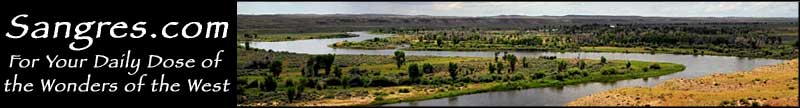
On the eastern side of the Bighorn Mountains on the Bighorn Scenic Byway

Bighorn Scenic Byway area map
Medicine Wheel Passage Scenic Byway
