 |
Payette River Scenic Byway |
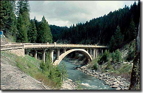 Rainbow Bridge over the Payette River |
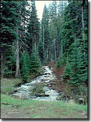
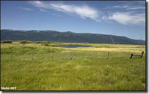
Warning: the Payette River Scenic Byway is so surrounded by beautiful but very distracting river, mountain, forest and wildlife scenery that driving the road is bordering on dangerous. The Payette River Scenic Byway passes through some of Idaho's most beautiful mountain/forest country as it makes its way north from Eagle to New Meadows. Along the way, the route passes by several historic lumber towns, 2 state parks and 4 good ski hills. As beautiful as this area is in the summer, winter is when it really comes into its own as a destination for skiers, snowboarders and snowmobilers. I got a bit ahead of myself there: summer sees lots of anglers, campers, hikers, rafters and bird watchers in this gorgeous countryside. Then when that blanket of snow comes... The Payette River is one of Idaho's premier whitewater rafting streams with mile after mile after mile of rapids (the North Fork of the Payette has 15 miles of steady Class V rapids and is rated for experts only). There are occasional pullouts along the road to allow you to stop and get out and take a look safely. Some of them are close enough to the tumbling water that you can even feel the pulse of the river... although the water flows do open out and relax in areas like Payette Lake and Cascade Reservoir. The main branch of the Payette along the byway (from Banks to Horseshoe Bend) is mostly Class III and lower, while the South Fork is famous for its long stretches of Class IV whitewater in the Canyon and Staircase sections. As a lot of this scenic byway passes through sections of the Boise and Payette National Forests, there's plenty of opportunities to catch some great views of wildlife. Bird watchers tend to head straight for the Hembrey Creek Wetlands, a beautiful stop-over for migratory birds along the Pacific Flyway. There's red-tailed hawks, golden eagles, osprey, Merriams turkey, Boreal owls, Red-crested pileated woodpeckers, peregrine falcons, American kestrel, western tanagers, broad-tailed hummingbirds, California quail, western screech owls and multitudes of other waterfowl and raptors. Enough summer, now I can go back to winter: there's 250 miles of groomed snowmobile trails accessible from Smith's Ferry, with another 800 miles of groomed snowmobile trails in the Cascade area. Cascade also offers about 44 miles of groomed cross-country ski trails. Then there's the ski hills: Bogus Basin, Brundage, Tamarack, Little Ski Hill... maybe that's why this route is also known as the Winter Wonderland Trail. The Payette River Scenic Byway begins where Idaho Highway 55 begins: at the junction with Idaho Highway 44 west of Boise. From that point the route goes north through the mountains, past Bogus Basin Ski Ski Area to Horseshoe Bend where it meets the Payette River. Then the road continues north alongside the river through the towns of Cascade and McCall to end in New Meadows at the junction with US Highway 95. At Banks (just north of Horseshoe Bend) is the junction with the Wildlife Canyon Scenic Byway, a route that heads east into the mountains through the valley of the South Fork of the Payette River. If you're a whitewater enthusiast or a fisherman, either of these routes beside those mesmerizing rivers can be very distracting. Near Cascade is Cascade Reservoir and the popular Lake Cascade State Park. The state park and the national forest that abuts the state park are filled with hundreds of miles of summer hiking and biking trails that become groomed snowmobile, snowshoeing and cross-country skiing trails in winter. On the backside of the lake is Tamarack Resort with an excellent ski hill and gold course. The area around McCall is similar, except the McCall area is also home to Ponderosa State Park, Brundage Mountain Ski Resort and Little Ski Hill. The valleys and mountains around the Payette River are a veritable wonderland of recreational activities with campgrounds, national forest access, pull-outs to access the river and some beautiful spots to just stop, smell the trees and watch the wildlife. Just south of Banks is where you'll find the terminus of the Thunder Mountain Historic Train Ride, a scenic railroad that ventures into the mountains and along the river in the summer time, running under the Rainbow Bridge to Smith's Ferry and back again. From end to end, the Payette River Scenic Byway is almost 112 miles long. You could drive it in a couple hours... but what a waste of gorgeous countryside. |
 Hembrey Creek Wetlands along the Payette River Scenic Byway 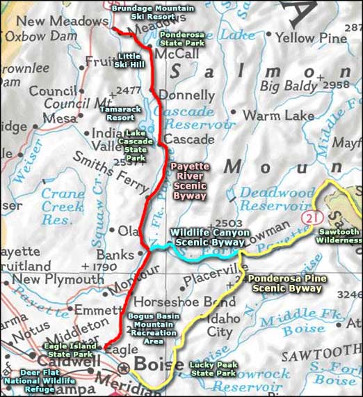 Payette River Scenic Byway area map |
|
|
Payette River Scenic Byway Related Pages
Lake Cascade State Park - Ponderosa State Park - Bogus Basin Ski Area
Brundage Mountain Ski Resort - Little Ski Hill - Tamarack Ski Resort Wildlife Canyon Scenic Byway - Ponderosa Pine Scenic Byway Deer Flat National Wildlife Refuge - Sawtooth Wilderness Lucky Peak State Park - Eagle Island State Park Idaho Pages |
 |
| Index - Arizona - Colorado - Idaho - Montana - Nevada - New Mexico - Utah - Wyoming National Forests - National Parks - Scenic Byways - Ski & Snowboard Areas - BLM Sites Wilderness Areas - National Wildlife Refuges - National Trails - Rural Life Advertise With Us - About This Site - Privacy Policy |
| Rainbow Bridge photo courtesy of Marianne Piquet, © Sage Community Resources, Byways.org. Area map courtesy of National Geographic Topo! Text Copyright © by Sangres.com. All rights reserved. |