 |
Pioneer Historic Byway |
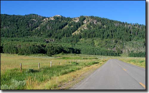 This is where the Lander Cutoff of the Oregon Trail crosses the Pioneer Historic Byway |
Pioneer Historic Byway is a 127-mile journey into the history of southeastern Idaho. At the southern end of the Byway is Franklin, the earliest surviving settlement in Idaho. Franklin was first settled by Mormon pioneers in 1860. Over the ensuing years, the Mormons continued to arrive and built many of the stops along the Pioneer Historic Byway. Soda Springs has a captive geyser in town and is near Sheep Rock, that place where the historic California and Oregon Trails really diverged. It was north of here that the Lander Cutoff rejoined the main route of the Oregon Trail (on what is now the Fort Hall Indian Reservation). Franklin was originally settled by 13 Mormon families who thought they were still in Utah. In 1872, Federal surveyors came through and discovered that Franklin was 1 mile north of the actual state line. Today, Franklin is home to a well-developed historic district that offers many historic homes and other buildings for the avid "history-and-heritage tourist." Those early settlers put in an extraordinary amount of effort to build homes, establish farms and dig irrigation canals to bring water from the lakes and rivers to their fields. One of those canals was the Last Chance Canal which diverted water from the Bear River near Grace and, in a convoluted route, carried that water back across the river at the top of the gorge to get to the fields. The water flume is still in place, still in operation today. 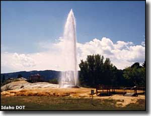
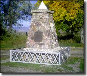
Preston is home to the Oneida Stake Academy, an impressive 3-story stone structure built to house an early Mormon school. About five miles northwest of Preston is the Bear River Massacre National Historic Site. This is a site where a unit of the California Volunteers attacked a winter encampment of Shoshone Indians in January, 1863. Estimates of Shoshone casualties vary from 250 to 493 but the whole event occurred because of the flood of Eastern emigrants into Shoshone territory forcing the tribe to the edge of starvation. To feed their people, the Shoshone had been raiding farms and ranches for whatever they could find to eat. The Indian Superintendent for Utah had warned the Federal government that trouble was brewing but with the Civil War raging in the East, settlement of the problem was left in the hands of the California Volunteers, a group of "American" soldiers who were unhappy with their assigned lot of policing the Mormons and Indians in Utah: they wanted to be in the East killing Confederates. There were several incidents between the Indians and the settlers and Army, then the Indians killed a Montana-bound miner who was lost and ended up almost on top of their camp on the Bear River. The miner's companions ran back to Salt Lake City and filed an affidavit accusing the Shoshone of several different atrocities and the military was unleashed. They attacked the Indian camp at about 6 AM on January 29, 1863, with deep snow on the ground and temperatures hovering around -20°F. Within a couple hours, the Volunteers overran the encampment and then began indiscriminately shooting people, raping the women, then killing them and the children. The women who wouldn't submit were killed first, then raped. Survivors were rounded up and shot with pistols at point blank range. When the shooting finally stopped, the camp was burned to the ground and the soldiers left. Surprisingly, a few Shoshone survived by hiding out in the Bear River and near some local hot springs. The Volunteers estimated 250 Shoshone dead while one Mormon emigrant who walked through the camp later that day said he counted 493 Shoshone bodies. Today, the Shoshone Nation owns the land around the site and has erected a monument and put several picnic tables and fire grates in place there. Soda Springs was founded in 1871 at the site of several geysers and geological springs. In the earlier days, Sheep Rock near Soda Springs was the site where the main route of the California Trail split off from the main route of the Oregon Trail. In a city park in the center of Soda Springs is the famous Captive Geyser: a cold water geyser that erupts regularly as a result of carbon dioxide pressures underground. The geyser is capped and controlled by a timer that usually allows it to vent every hour, on the hour. 
North of Soda Springs, the Pioneer Historic Byway runs past several interesting geological sites before turning east to pass by Grays Lake National Wildlife Refuge (a major stopping-and-resting point along the Pacific Flyway for migratory waterfowl and other birds), cross Tincup Canyon and end at the Wyoming State line. Near Grays Lake is where you'll cross the route of the Lander Cut-Off: a segment of the Oregon Trail that was surveyed and established in the late 1850's, just as traffic on the Oregon Trail was winding down. The Pioneer Historic Byway is paved the whole way but, depending on recent snowfall, the section between Soda Springs and the Wyoming border is sometimes closed in winter. Off the beaten path (but still close by) is the ghost town of Chesterfield. Founded in 1880 along the wheel ruts of the Oregon Trail, Chesterfield grew to about 400 inhabitants before folks were driven out by years of bad weather and bad fortune. A lot of what remains of the town is now on the National Register of Historic Places. Probably the best-preserved structure in Chesterfield is the Chesterfield Meetinghouse, which has been leased to the Daughters of the Utah Pioneers for use as a museum. Apparently the original pump organ still works and visitors have been known to try their hand... Also nearby (and off the beaten path) is Red Rock Pass. During the last Ice Age, glacial meltwater had formed Lake Bonneville to the south. What's left today of Lake Bonneville is Great Salt Lake but 14,500 years ago, the water level was much higher and covered a large part of ancient Utah and southeastern Idaho. Red Rock Pass is the place where that water finally breached the rock ridges holding the meltwater in and the resulting catastrophic flow is now known as the second greatest flood in global history. It was that flood that carved a lot of the Snake River Canyon and Columbia River Gorge, moving house-sized boulders hundreds of miles downstream. The flood waters raged for months as the level of Lake Bonneville dropped some 300 feet and the surface area of the lake was drastically reduced. |
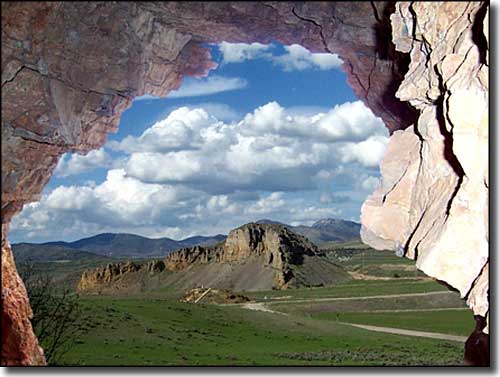 Red Rock Pass 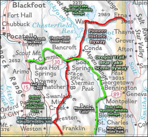 |
|
|
Pioneer Historic Byway Related Pages
Grays Lake National Wildlife Refuge - Caribou-Targhee National Forest
Oregon Trail-Bear Lake Scenic Byway - Bear River Massacre National Historic Site Bear Lake National Wildlife Refuge - Oxford Slough Waterfowl Production Area Bear Lake State Park - Pebble Creek Ski Area Idaho Pages |
 |
| Index - Arizona - Colorado - Idaho - Montana - Nevada - New Mexico - Utah - Wyoming National Forests - National Parks - Scenic Byways - Ski & Snowboard Areas - BLM Sites Wilderness Areas - National Wildlife Refuges - National Trails - Rural Life Advertise With Us - About This Site - Privacy Policy |
| Upper photo of the Lander Cutoff to the Oregon Trail courtesy of Tony Varilone Upper left photo of the Bear River Massacre Monument courtesy of Robert S. Horning, CCA ShareAlike 3.0 License. Photo of the Captive Geyser courtesy of Idaho DOT. Photo of Last Chance Canal courtesy of John Bertram via Byways.org Photo of Red Rock Pass courtesy of Ann Yearsley, Byways.org Map courtesy of National Geographic Topo! Text Copyright © by Sangres.com. All rights reserved. |