Fort Laramie, Wyoming

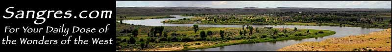
The townsite of Fort Laramie is located directly across the North Platte River from its namesake, Fort Laramie, a military garrison that was built on the Oregon/California/Mormon Pioneer Trails and served as a resting and re-stocking place for travelers along the North Platte River for many years. However, with the construction of the Transcontinental Railroad and the conclusion of the Indian Wars in 1878, Fort Laramie quickly lost importance and was soon decommissioned by the federal government.
The original Fort Laramie is now the Fort Laramie National Historic Site, and the folks who work there live across the North Platte in "new" Fort Laramie.
Most folks who come to visit Fort Laramie do so by driving along the Oregon Trail Historic Byway.
Latitude: 42.2132°N
Longitude: 104.5171°W
Elevation: 4,239'
Education:
High School or Higher: 73.9%
Bachelor's Degree or Higher: 9.9%
Graduate or Professional Degree: 1.8%
2011 Cost of Living Index for Fort Laramie: 80.7
Median Resident Age: 44.7 Years
Estimated Median Household Income: $32,500
Estimated Median Home Value: $58,790
Population Density: 879 People per Square Mile
Major Industries:
Rail Transportation, Lodging & Food Services, Educational Services, Construction, Entertainment & Recreation, Government, Professional Services, Agriculture
Unemployed (March 2011): 6.2%
Population Demographics: 2010
| Total Population | 230 |
| Males | 123 |
| Females | 107 |
| Population by Age | |
| Under 18 | 42 |
| 18 & over | 188 |
| 20-24 | 7 |
| 25-34 | 24 |
| 35-49 | 39 |
| 50-64 | 58 |
| 65 & over | 56 |
| Population by Ethnicity | |
| Hispanic or Latino | 13 |
| Non Hispanic or Latino | 217 |
| Population by Race | |
| White | 211 |
| African-American | 0 |
| Asian | 0 |
| Native American | 3 |
| Hawaiian or Pacific Islander | 0 |
| Other | 9 |
| Two or more | 7 |
Hawk Springs State Park - Fort Laramie National Historic Site
Oregon Trail Historic Byway
