Red Gulch-Alkali Back Country Byway
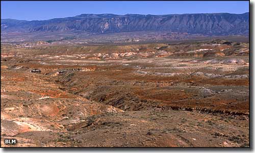
Alkali Creek area, western foothills of the Big Horn Mountains

The Red Gulch-Alkali Back Country Byway is composed of about 32 miles of serious back roads that parallel the western edge of the Big Horn Mountains (and Bighorn National Forest) between Hyattville and Shell. This 32 miles may take you up to 2 hours to drive over gravel and improved dirt roads (unless the ground is wet, in which case it could take days...)
The northern access to the Byway is via US Highway 14, about 4 miles west of Shell. The southern access is via Wyoming Highway 31 north of Hyattville.
Driving this road will also bring you to the Red Gulch Dinosaur Track Site, the largest dinosaur track site in Wyoming.
The Red Gulch-Alkali Back Country Byway is usually drivable from May through October. In dry times the road can be driven easily by a high-clearance 2WD vehicle. However, even light rain can quickly make even 4WD impossible... and some of the countryside you'll drive by on this route is part of the Alkali Creek Wilderness Study Area. You'll also pass by some steep, heavily eroded canyons cut into the face of the Big Horns that can offer some interesting and challenging hiking opportunities. Medicine Lodge Canyon is one of these where the stream offers some excellent trout fishing, too. Close by there is the Medicine Lodge State Archaeological Site with its dinosaur fossil digs. Beyond that is the Medicine Lodge Wilderness Study Area. A few miles north of the junction of the Alkali Creek Road and the Red Gulch Road is the rim of Trapper Canyon. This is also a spectacular canyon cut into the mountains and home to the Trapper Creek Wilderness Study Area. Access to Trapper Canyon is extremely hard and requires that you get permission to cross private land first.


Red Gulch area

Red Gulch-Alkali Back Country Byway area map
