 |
Downey, Idaho |
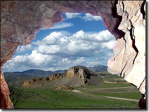 Red Rock Pass |
|
Downey was settled by Mormon pioneers in the early 1900's. Back in those days, there were Mormon settlements just about every 10 miles or so but over time, many of those original towns dwindled away and were abandoned, the remaining folks moving to places like Downey, McCammon, Preston, Malad City... As it is now, many of these towns are also slowly dwindling away as the migration to the bigger cities for work just keeps growing. The Downata Hot Springs Resort is located about 4 miles south of Downey, off of Highway 91. Close by is Red Rock Pass, that place where the natural dam that held ancient Lake Bonneville back finally broke through and allowed the huge Bonneville Flood to happen about 16,800 years ago. |
| Fast Facts about Downey, Idaho |
|
Downey, Bannock County, ID 83234
Founded: 1907 Elevation: 4,865' Latitude: 42.4293°N Longitude: 112.1224°W Resident Racial Breakdown: White Non-Hispanic: 96.4% Hispanic: 1.1% Other: 0.9% Two or More Races: 1.6% Education: High School or Higher: 83.6% Bachelor's Degree or Higher: 9.6% Graduate or Professional Degree: 1.8%
2009 Estimates: Population: 592 Males: 291 Females: 301 Median Resident Age: 38.6 Years Estimated Median Household Income: $39,800 Estimated Median Home Value: $87,600 Population Density: 601 People per Square Mile 2011 Cost of Living Index for Downey: 83.7 Major Industries: Agriculture, Construction, Transportation Services, Health Care, Building Materials, Finance & Insurance Services, Lodging & Food Services, Educational Services, Information & Data Services, Government Unemployed (March 2011): 9.2% |
|
|
 |
| Index - Arizona - Colorado - Idaho - Montana - Nevada - New Mexico - Utah - Wyoming National Forests - National Parks - Scenic Byways - Ski & Snowboard Areas - BLM Sites Wilderness Areas - National Wildlife Refuges - National Trails - Rural Life Advertise With Us - About This Site - Privacy Policy |
| Photo of Red Rock Pass courtesy of Ann Yearsley, via Byways.org Text Copyright © by Sangres.com. All rights reserved. |